BLOG
Reason 1: Sossusvlei and Deadvlei
Namibia’s name is derived from the Khoekhoegowab word “ Namib” meaning “vast place”. Often dubbed as the land of open spaces, Namibia is the land where the desert meets the sea, and home to the Namib Desert, one of the oldest deserts in the world. With bountiful wildlife, beautiful landscapes, and warm, welcoming people, Namibia is a must for those travelling to Africa. Boasting more than 300 days of sunshine a year, Namibia allows travelers to experience its lush vegetation in the Zambezi region, the arid Kalahari to the East, the dry Namib Desert and the cool Atlantic Ocean to the West, and the Fish River Canyon to the south.
FUN FACTS ABOUT NAMIBIA
- Namibia was the first country in the world to include environmental protection and conservation in its constitution.
- Namibia became an independent nation on 21 March 1990.
- Namibia has more than 11 indigenous languages, and English is the country’s official language.
- Namibia is an animal lover’s paradise, and it has over 200 species of mammals, 600 species of birds, and 250 species of reptiles.
- Namibia is home to the largest canyon in Africa, the Fish River Canyon.
- Namibia is home to the oldest desert in the world, the Namib Desert, which is more than 55 million years old.
365 kilometres southwest of Windhoek lies Sossusvlei, one of Namibia’s most breathtaking landmarks.
With towering red sand dunes over 200 metres tall, this otherworldly landscape is a must when visiting Namibia. Derived from the Khoekhoegowab ‘Sossus’ meaning point of no return or dead-end and ‘Vlei’ the Afrikaans word for a marsh, ‘Sossusvlei’ means ‘Dead-end marsh’. Sossusvlei looks like a surreal dreamscape at the end of the world. The tallest dune is aptly named ‘Big Daddy’,’ which is more than 325 metres high. If you want to attempt to climb this mega dune, we suggest heading out early in the morning before the sun is at its peak and begins to scorch the sand. While you might have to crawl up on your hands and knees as you try to reach the top, we can assure you that the panoramic views from the top of ‘Big Daddy’ are absolutely worth it.
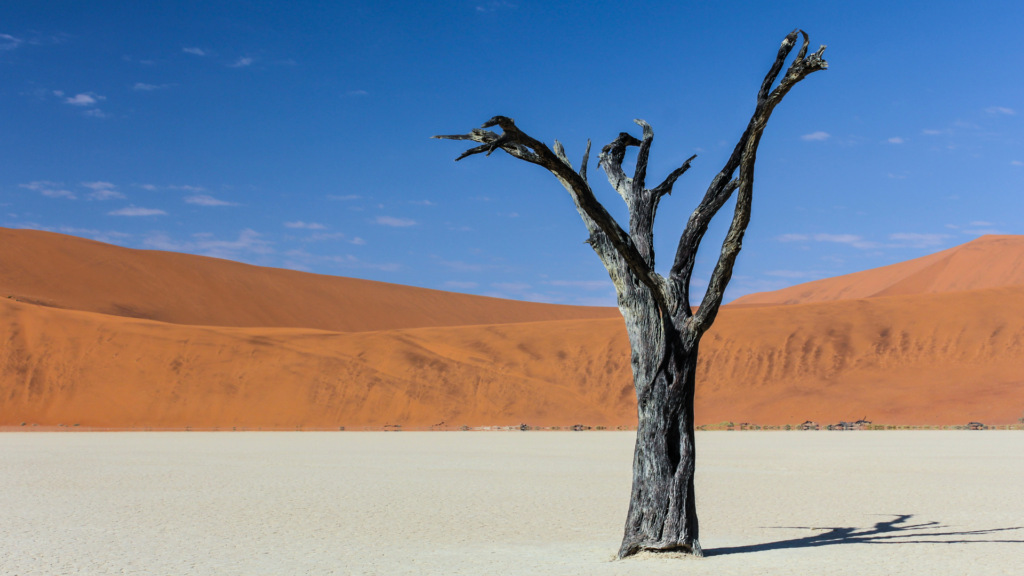
Deadvlei
A 2-kilometre walk from Sossusvlei leads you to Deadvlei, another dried up marsh which can only be reached by foot. The bleached white clay pan, dark trees, and rust-red dunes create a striking contrast with Namibia’s clear blue skies, making Deadvlei one of Namibia’s most photographed attractions. It is hard to picture that this vlei was once flooded with the Tsauchab River. The fossilized trees scattered along the pan died almost 900 years ago when the river became blocked off by the encroaching dunes.
Despite its dry and harsh climate with temperatures reaching up to 40 Celsius during the day and below freezing at night, life persists. Animals and plantlife have been able to adapt to the area.
You can encounter some herbivores (gemsbok, springbok, ostrich), predators (jackals, spotted and brown hyena) and smaller animals like porcupine and aardwolf, as well as a variety of small desert creatures like insects, spiders, geckos, and other reptiles.
Travel Tips: We suggest carrying some water, applying sunscreen, wearing a hat and comfortable walking/hiking shoes.
Did you know:
- ‘Big Daddy’ is the second tallest dune in Namibia at 325 metres. [Dune 7 near Walvis Bay is 383 meters tall.]
- The Namib-Naukluft is one of the largest national parks in Africa.
- The sand in Sossusvlei is more than 5 million years old and gets its red colour from the oxidation of the iron particles in the soil over time.
Reason 2: Fish River Canyon
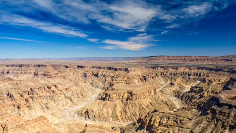
560 kilometres south of Windhoek lies the Fish River Canyon. The canyon is 160 kilometres long, 27 kilometres wide, and up to 500 metres deep in some areas, making the Fish River Canyon the largest canyon in Africa and the second largest canyon in the world. The Fish River’s source is east of the Naukluft Mountains pooling into the Hardap Dam near Mariental and heading south towards ǀAi-ǀAis/Richtersveld Transfrontier Park until it flows out into the Orange River.
Nama Folklore
A long, long time ago, there lived a large serpent in the south of Namibia with a diamond encrusted on its forehead. The serpent used the diamond as a light to help navigate in the dark, where it would terrorize the people and eat their livestock. The elders would warn everyone to be on a look out for a bright light in the dark, a sign that the serpent was lurking around, preying on its next victim. The people got tired of being stalked by the serpent and decided to end its reign of terror. Attacking it with fire and spears, the serpent thrashed about with its dying breath hitting its body on the ground. The serpent’s body created large crevices in the earth, forming the FIsh River Canyon.
Tips
The best time to hike the canyon is between May and September (Namibia’s Autumn and Winter), when the weather is a bit cooler. The Canyon is closed in the summer due to the blistering heat. You also need to provide a medical health certificate no older than forty days to let authorities know that you are fit to hike the canyon.
Did you know
- That ǀAi-ǀAis means “hot or burning water” in Khoekhoegowab.
- The Fish River flows into the Hardap Dam near Mariental, The Hardap Dam is Namibia’s largest dam
- The Fish River is the second largest canyon in the world, after the Grand Canyon in the U.S.
Reason 3: Etosha National Park
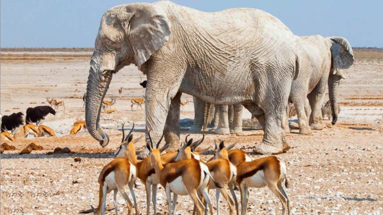
400 kilometres North of Windhoek lies Etosha National Park, Namibia’s most popular national game park. Etosha is derived from the Oshindonga word ‘Etotha’ meaning ‘place where plants don’t grow’ or ‘great white place’, it colloquially became known as ‘Etosha’ because European traders had troubles pronouncing the original word. Around 16,000 years ago the pan used to be a lake filled with water that flowed from the Kunene River, but over time, the course of the river shifted, slowly drying up the lake and only leaving the white salt pans behind. During the rainy season, a shallow lagoon is formed in the pan again, forming a large watering hole for the national park’s wildlife, which includes lions, leopards, rhino, wildebeest, cheetahs, elephant, giraffe,zebra, and 106 other species of mammals. Etosha is home to more than 110 species of reptiles, 340 species of birds, as well as other insects and amphibians.
Hai||om San Folklore
A long time ago there used to be a small village where the Etosha Pan is today. One day the village was attacked by raiders who killed all the men and children but spared the women. One woman was so distraught about the loss of her husband and children that she howled and wept for days. Her tears formed the lake, when her tears dried up, all that was left was a pile of salt, which formed the Etosha Pan.
Did You Know:
- Etosha Pan is so large it can be seen from space.
- Etosha was proclaimed a national park in 1907.
- The Etosha Pan is a breeding ground for flamingos during the rainy season, and it can have up to a million flamingos during very good years.
Reason 4: Kaokoland
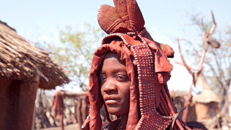
730 kilometres northwest from Windhoek lies Opuwo, Kaokoland’s capital in the Kunene Region. Opuwo’s original name was Otjihinamaparero by the ovaHimba people, but it was changed to Opuwo by the Colonial Official Carl ‘Cocky’ Hahn, meaning ‘finished’ or ‘enough’. Kaokoland is the home to the Ovahimba people, as well as some Herero people. Kaokoland is bordered by Angola to the north along the Kunene River, Owamboland to the east, the Hoabib River to the south and the Atlantic Ocean to the west. Kaokoland is a dry, arid climate with mountain ranges, grassland, and succulents. Water is scarce in most of Kaokoland except for on the banks of the Kunene River.
Epupa Falls
Near Epupa village lies the Epupa Falls, where the Kunene River flows down a forty metre-high gorge. Epupa means ‘falling water’ in Otjiherero. The best time to see the falls are between April and May.
OvaHimba Folklore
Fairy Circles are round patches of barren land without any vegetation. Fairy circles vary in size and can be anything between 2-15 metres in diameter. Fairy circles are found in the Kaokoveld. According to OvaHimba folklore, fairy circles are the footprints of spirits and of Muruku, their original ancestor and God.
Reason 5: The West Coast
Namibia’s coastline is 1,572 kilometers long, running from the Kunene River in the northwest all the way down to the Orange River in the south. The place where the desert meets the sea, Namibia’s coastline is a must when travelling.
Skeleton Coast
The northern part of Namibia’s coastline is known as the Skeleton Coast; it is approximately 500 kilometres long and 40 kilometers wide. It got its name from being littered with skeletons of whales and seals washed ashore, as well as from many ships which met their untimely demise. Despite it’s harsh climate, you can still find the occasional desert lion, desert elephant, rhinoceros, zebra, as well as hyena in some areas. It is a great place for fishing and angling, but we wouldn’t suggest swimming in the ocean due to the strong winds and currents, as well as rocky coastline.
Cape Cross
400 kilometres northwest of Windhoek, you will find Cape Cross: the breeding grounds of the large Cape Fur Seal Colony. During the breeding seasons of November and December, more than 200,000 seals congregate at Cape Cross. The stone Cape Cross, or Padrão, was first erected in 1486 by Portuguese explorer Diogo Cão, the first European to visit the area. A replica of the cross still stands where Diogo Cão erected the original en route in his expedition to find a sea route to India and the Spice Islands. In the 1800s, guano was harvested and exported to Europe for use as fertilizer and gunpowder.
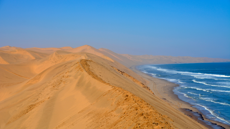
Sandwich Harbour
80 Kilometres south of Walvis Bay lies Sandwich Harbour, which forms part of the Namib Naukluft Park. It is made up of a shallow lagoon in the south and a bay in the north, sporting spectacular views of giant dunes disappearing into the sea. Sandwich Bay is also a popular 4×4 destination. You can spot some oryx, springbok, jackals, and ostriches in the area, as well as stunning birdlife such as flamingos and pelicans. Some of the natural desert vegetation includes the !nara plant, which despite its prickly exterior can be a great source of water and a meal with its fleshy fruit.